Tuesday, December 6, 2011

Hungry like a Wolf

***Sorry for the lack of pics, but the light sucked and the snow was deep, so priorities were on the riding***


Desperate times call for desperate measures. Its been over a month since the last significant storm in the front range, and a serious jones for a powder day had set in. Obsessively watching the satellite hoping for some moisture only to be let down again and again finally paid off as Wolf Creek was at the epicenter for an impressive 4day storm cycle. Waking long before the sun, Brian and I made the 4hour drive south to get on the goods.

My alarm shocked me to consciousness at 4:50am. Stumbling around my girlfriend's room in the dark I rounded up my layers, gear, and a quick breakfast before leaving Frisco to meet my buddy Brian in Breckenridge for the long haul down to Wolfie through the early morning hours. Admittedly, I slept for most of the drive, occasionally catching glimpses of the surrounding countryside as my eyes would open for brief moments of awareness. Vast high-plains of frozen sagebrush ringed by mountains would flash as snapshots in between extended periods of nothing. This harsh landscape was rugged and vast, a place where cattle outnumber people, cowboy country. Adding to the sense of desolation was the frigid, still air mass that had entrenched itself over much of Colorado in the passing of the front responsible for all the snow brought to Wolfie. Daytime temps would not reach 5 degrees, and everywhere the air seemed to be frozen in a haze of low, but thin clouds.

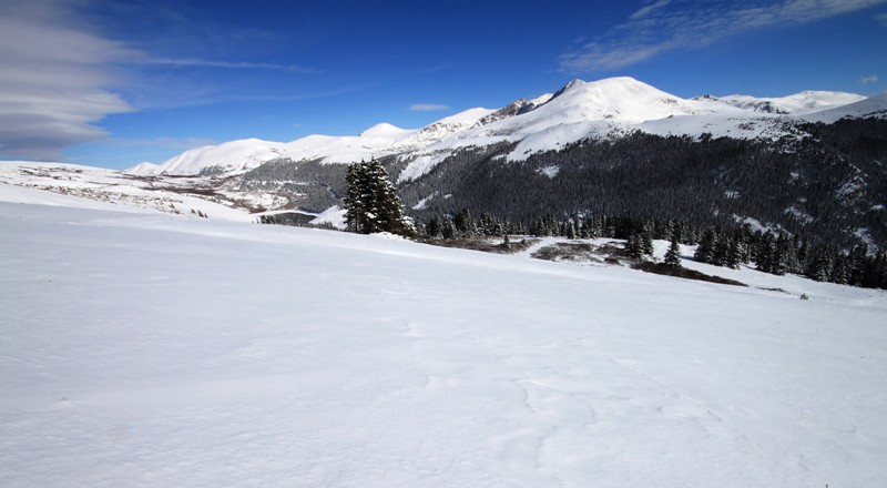
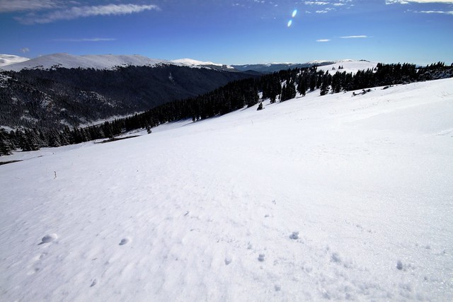
Reaching Wolf Creek shortly after 9am, Brian and I were stoked to find a parking lot nearly as empty as the open ranges we had passed on our drive down. Scoping the terrain that lay before us, stoke levels began to rise. The old growth conifers were coated in white calling to mind images of the Northwest in a place far, far from the abundant moisture of the Pacific Ocean. Cliffs, spines, and steeps were all within reach and after a short hike out toward Alberta Peak we were waist deep in some of the lightest snow I've ever ridden.

This would be a good time for me to mention that Wolf Creek isn't exactly an ideal place to ride as a snowboarder. While the Wolf does have plenty of steep terrain littered with cliffs and pillows, it is very benchy as well. Short sections of truly steep terrain are separated by long, long sections of flats that can be a serious pain in the ass if you don't keep your speed up. Additionally, nearly every good section of terrain at Wolfie requires a forever long traverse back to the lifts via a flat, and often times, slightly up-hill cat-track. If you find yourself eyeing a trip to Wolf Creek, bring poles or a split-board, you will thank me later. Still, if you're smart about where you ride, you can minimize the time spent walking/skating along the dreaded cat-tracks; but understand that at Wolf Creek you're probably going to have to do some walking to get back to the lift. This isn't all bad however, as Wolfie's isolation keeps the crowds to a minimum so there is no sense of urgency on a mid-week pow day. In fact, Brian and I discussed (while walking back to the lift) how riding there is very similar to riding slackcountry at your favorite resort: Deep snow, not many people around, and some effort required to reap the goods.

I couldn't get over how empty it was down there. We rode untracked lines literally bell to bell, and when we left there were still plenty of lines to be had on the mountain that hadn't seen a soul all day. Add to that the fact that the Wolf has some solid, if short terrain, and you're guaranteed to have a good time if you happen to find yourself in south central Colorado while a low-pressure system is sweeping through the desert southwest. If for some reason you find conditions in-bounds to be beat the surrounding backcountry should keep you occupied for sometime, so come armed with a splitter, or snow-shoes and go get yourself some. You'll be glad you made the drive.

Areas worth checking out:
Alberta Peak
The Waterfall zone
Knife Ridge (accessed via Alberta lift)
Bonanza Cliffs

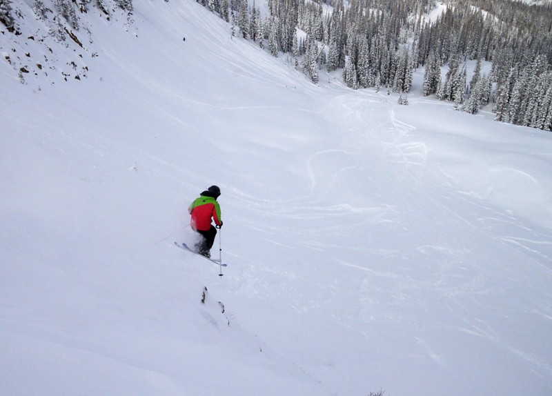
Brian sends one in the Bonanza Cliffs area near the end of the day.
Bhuckweb

deepwolf
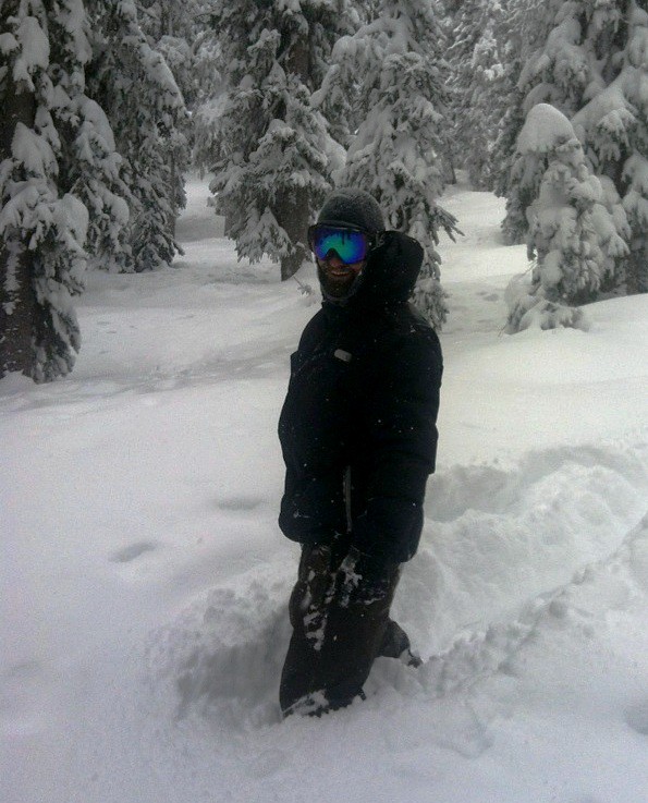
I got eaten by the Wolf a couple of times in the flats, so much snow!!!. Photo cred: Brian Lindahl

Friday, October 28, 2011

Seeking Solitude in the Front Range

With the first solid dump of the year on the ground I was eager to get away from the lift-accessed crowd, so I headed up to the secret stash to find some soft snow and solitude in the often crowded front range backcountry....

Bierstadt2web

A potent early season upslope storm delivered 18-24" across the Front Range this week. The lift accessed riding at the Luv on Wednesday was great with 21" falling in less than 24hrs. Pre-halloween faceshots were had in the morning, but with only 3 runs open, the snow went fast. I decided after hearing a few reports from friends that had been out on Loveland Pass to head up the secret stash east of the Divide that Cory and I had been scouting these past few weeks. Its not as vast or as gnarly as Berthoud, but it is off of most people's radar which is nice since so many BC spots around here are crawling with mountain jocks from Denver covered in North Face gear pushing their tele's up the skin track. The stash allows for an escape. Although there was one other car at the trailhead, I never saw the other party all day. As I hiked my way up the winding trail, the new snow swished under my feet and glistened like a million diamonds illuminated by the bright sun. I made it to the top in around an hour, had a bite to eat, and dug a quick hand pit before dropping into the wide-open mellow bowl below me.

GB1
I had this all to myself. Sometimes its just not fair.

I stuck to the upper elevations of the stash as I was concerned there wasn't enough coverage for a full lap, and even though I managed to scrape bottom a couple of times, overall the snow was awesome. Remember, its not even Halloween yet.

Solitudekeep
Solitude found at the stash.

I made a couple of more laps through the bowl before deciding I should probably head down before I was late for work. Along the way I dropped into another line I had scouted earlier this fall that I knew had minimal rocks for a few more fun, fast turns.
Solitudekeep2

There is something pretty special about looking back up a slope and seeing only your tracks on it. Until next time....

Wednesday, July 6, 2011

Show me your 'O' face...Snowboarding on the 4th of July

There is something really special about making turns in the summer, especially if the snow is still good. You say to yourself, "Its July, and I'm making turns....HOLY SHIT!!! ITS JULY AND I'M MAKING TURNS!!!". For countless summers growing up I would periodically have snowboarding dreams only to wake up disappointed to look out my window to see green grass instead of a blanket of white. Regardless of how many years I've been riding, getting to make turns any time after about mid-may is a huge source of stoke.

Perhaps its simply the novelty factor, or perhaps its the fact that you know that everyday deeper into summer decreases the likelyhood that you'll be riding tomorrow. Toward the end of June, any day you get to spend on your board is like living the mid-summer snowboarding dreams you'd have as a kid, except when you pinch yourself you don't wake up disappointed...hell, you don't wake up at all because you're there, living it; its truly surreal, like a lucid dream.

Contributing to the dream-like state, I got out of work around 10pm, rounded up my gear and made the 1 hour plus drive up to the old ghost-town/mine site of Waldorf. Tired from a long shift at work, I met up with Cory, and his friend Zaida. Cory and I had been discussing riding a line off the summit of Argentine Peak for the past couple of weeks, but couldn't seem to get our schedules to align enough to make a go at it. However, it became readily apparent at first light that things on Argentine had melted out significantly since my scouting mission up there only a week and a half prior. Still, there were aspects holding plenty of snow and one line off the eastern flanks of Mt. Edwards caught our eye. We made breakfast under a hot, rising summer sun and set off with eyes still burning from a lack of sleep in a half-conscious state. We quickly settled into the 'click-clack' rhythm of hiking and our bodies slowly awoke with the rising sun. We reached the top of our line in a little under an hour and a half and relaxed for a bit in the ever increasing warmth of summer before dropping into 1200 vertical feet of smooth, but super slushy snow.

Driving up to Waldorf...
Photobucket

Jetboiling
up some oatmeal for breakfast (Photo: Cory Arola)
Photobucket

We all were a bit over dressed for the warm sunshine, but that didn't stop us from making good time up to the top of our line.

Cory and Zaida putting in work on the up...
Photobucket

It was Zaida's first back-country experience. Needless to say she's hooked.
(Photo: Cory Arola)
Photobucket

We had talked about doing a 14'er for the 4th, but decided against that since half of what draws us into the mountains and the back-country is the escape from the masses, the solitude that so many people now-days fear. If you've ever been on a 14'er in the front range during the summer, then you can appreciate what I mean.

Photobucket

Photobucket

Cory and Zaida relaxing in the summer sun and silence.
Photobucket

We were the only ones in the Argentine Pass area for our entire climb and our descent. Save for a curious Mountain Goat.

"Don't these assholes know its summer?"
Photobucket

Cory making his way down 'O'-Face.
Photobucket

Photobucket

Then it was Zaida's turn...
Photobucket

I then dropped from the spot I had been shooting from, about mid-way down the line. The snow was smooth, but slushy. Shit, I'll take what I can get in July. (Photo: Cory Arola)
Photobucket

Photo: Cory Arola
Photobucket

Needless to say, I was stoked to have just rode 1200 vertical feet continuously on the 4th of July. My latest riding date ever. (Photo:Cory Arola)
Photobucket

We stopped to admire our summer signatures...I mean, you have to right?
Photobucket

Photo:Cory Arola
Photobucket

It wasn't until we got back to the car that a family on 4-wheelers rolled up, breaking the silence of the day with their flatulent exhaust note. It was all good though as they were soon off on their way and we once again had the basin to ourselves.

I don't know what it is about this basin, but it is one of my favorite in the Front Range. Perhaps it's its lushness, or perhaps its the fact that the peaks that surround you are so close. What ever it is, I love it up at Waldorf.
Photobucket

Or maybe its because when I head up there, I always get to see the 'O'-face.
Photobucket

Back at the cars, we cracked a couple of cold ones, had a post-descent safety meeting and took in the views. Life is good.
Photobucket

Our route. (map overlay courtesy of Cory Arola)
Photobucket

'til next time....thanks for looking.

Wednesday, June 15, 2011

Y-RAG couloir; Mt. Evans, CO 14,254ft 6.15.11

I rode the Y-RAG couloir (as its known to a few people) on Evans yesterday with David Gidley. I can't call this a 14er report since we did the easy thing and took a car ride to the top of Evans, but this does represent the gnarliest line I've ridden to date, if only because I had to down-climb through the choke. To make matters worse, I managed to set myself up toe-side just above the down-climb making it that much harder to get my board off, and turned around so that I could make my way back on to the snow with my board on again where I feel a helluva lot more comfortable. I'm such a pussy in big terrain without my board on.

***A special thanks to David Gidley for shooting some great shots along the way. I really appreciate your willingness to contribute stoke to this blog David.***


A look at our line. Purple=riding Yellow=downclimb
Photobucket

The man and the mountain are one. David Gidley
Photobucket

Here I am enjoying my standard BC lunch of PB&J on top of the line.
Photobucket

A look at David down-climbing his way through the choke that is quickly melting completely out.
Photobucket

David making his way down the line below the choke.
Photobucket

pb. toe-side turn just below the choke.
Photobucket

And another one a little further down.
Photobucket

Walking out at the bottom along Summit Lake I was all smiles.
Photobucket

The riding lately has been pretty stellar, and I'm stoked to be getting after the kind of lines I dreamed of riding while living in the midwest. I can't tell you how happy I am to be back in the mountains.

Thanks for looking. PB.

Monday, June 13, 2011

Squaretop Mountain 13,794ft 6.11.11

Squaretop Mountain
Photobucket

Although summer weather is finally here in Colorado, the skiing and snowboarding in the high country remains fantastic for anyone willing to put the effort in to getting on the snow.

Last week I managed to ride three days in various locations, but had been wanting to get out with some other friends in some new spots. My friend Cory and I had discussed several possible options including: Mt. Evans (14,264ft), Mt. Sniktau (13,234ft), Squaretop Mountain (13,794ft) and Grizzly Peak (13,427ft) before finally settling on Squaretop. Squaretop is uniquely situated on the west-side of Guanella Pass nearly half-way between two sets of twin 14,000ft+ peaks: Gray's and Torrey's; and Bierstadt and Evans giving anyone that gains the summit of Squaretop some amazing vistas of these peaks.

Cory and I chose to approach Squaretop via a ridge-walk following the eastern flank of the mountain. From there it was a brief push up some steepish scree to the short ridge to the summit. Here are a couple looks at our route:

(maps courtesty of Cory Arola)
Photobucket

An overlay of our route onto Google Earth
Photobucket

The stats of the trip are as follows:
Total distance covered:5.16 miles (if I had to guess, it was about 3 miles of hiking to the summit from the lot and around 2miles or so of riding from the top of the snowfield to the road)
Total Ascent: 2000vertical feet
Total Descent: 2100vertical feet
Top Elevation:13,794ft


Its always nice to be able to descend further than you have to climb, especially when your elevation gains are measured in thousands of feet. That being said though, the hike was pretty tame and really enjoyable. Lines that require a lot of work to get to are hugely rewarding, but there's something really nice about a line you can put enough work into to feel tired at the end of the day, but not completely exhausted. Its definitely more fun that way. No question.

Ok, here are the shots...I'd like to take this opportunity to thank Cory Arola for helping out with the photo duties.

Cory near the start of our hike while the Sawtooth looms in the background.
Photobucket

Here I am working my way through the first bit of scree just a little higher up.
(photo copyright: Cory Arola)
Photobucket

This was our first good look at the Eastern, and North-eastern aspects of Squaretop. We originally had planned to descend one of the chutes on the NE side of the mountain down into the Silver Dollar Lakes drainage, but with a lack of coverage we opted for the obvious snowramp down from the false summit into the cirque which contains the Squaretop Lakes.
Photobucket

We hiked on a little further to the base of the scree covered shoulder where we had a quick snack and enjoyed the high-alpine views.

One of the best parts about being in the backcountry is the sense of solitude, humility, and peace one gets high in the mountains. The effort put in is worth every drop of sweat.
Photobucket

Cory taking it all in.
Photobucket

We pushed on up the shoulder, drawing ever closer to the top of our line. Mt. Bierstadt, The Sawtooth, and Mt. Evans dominate the view to the East.
Photobucket

Cory offers a sense of scale (lower-left frame)
Photobucket

Cory puttin' in work on the up.
Photobucket

We got to the top of our line and decided we still had time to make the short push to the summit.

A view from the top with Gray's and Torrey's in the distance. (photo copyright: Cory Arola)
Photobucket

Cory with an obligatory summit shot.
Photobucket

I apologize for the lack of action shots with this post; but with it being fairly late in the day (12:30), and with convective storms building around us we figured we should descend fairly swiftly.

We were a little worried about how the snow was going to be on the top of our line when we saw this. (photo copyright: Cory Arola)
Photobucket

But once the slope rolled off to an angle that wasn't receiving nearly direct overhead sun, we were rewarded with some awesome smooth, surfy corn.

Cory on the run-out of the upper section of the line.
Photobucket

He was stoked to have just laid down such nice turns during mid-June.
Photobucket

A look back at our turns on the last pitch of the upper portion of our line.
Photobucket

From there it was a short walk around one of the Squaretop Lakes. (Notice the weather pushing in)
Photo copyright: Cory Arola
Photobucket

Many may not realize this but "The Point" was originally implemented by Sir Anthony Farnsworth Tallywacker-Polecock III esq. during his 1873 mission to the South Pole. Here I am keeping tradition alive with a textbook "Tallwacker-Polecock" point back at our line. (photo copyright: Cory Arola)
Photobucket

The sun poked back out long enough for Cory to pop off this shot of the upper portion of our descent. (photo copyright: Cory Arola)
Photobucket

From Squaretop Lakes we were able to connect up with a snow-filled gully that would lead us nearly all the way back to Guanella Pass road. The turns down the gully were awesome. The snow was a little sticky, but not bad. And to be able to continue to ride so far down the mountain blew our minds. It was like Squaretop had rolled out the white carpet for us. At the road we were fortunate enough to catch up with another party that had just finished skiing the same line. Those guys gave us a lift back to my car about a mile or so back up the road. Normally, I would've been game to walk back to the car, but since I had to work at 4, we were already pushing it.

A look at the full line. We caught the gully that runs diagonally through the left part of the frame.
Photobucket

All in all it was a fantastic day in the Colorado Front Range. Thanks for looking. PB.